Where is Denmark Located?
Where is Denmark located on the map? Denmark is an independent nation located in Northern Europe. Check out the following images to see location of Denmark on maps.
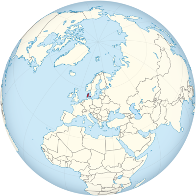
Denmark Location in World Map
Denmark is marked in red.
Location Information of Denmark
Denmark is a Scandinavian country located in Northern Europe, known for its rich history, advanced welfare state, high quality of life, and stunning natural landscapes. As a member of the European Union and one of the founding nations of the North Atlantic Treaty Organization (NATO), Denmark plays a crucial role in both regional and international politics, economics, and cultural exchanges.
Latitude and Longitude
Denmark is positioned at Latitude: 56.0° N and Longitude: 9.5° E. It is located to the north of Germany, south of Norway, and west of Sweden, with the North Sea to the west and the Baltic Sea to the east. This geographic positioning gives Denmark a significant maritime and trade history, influencing much of its cultural and economic development.
Capital City and Major Cities
Capital City: Copenhagen
Copenhagen is the capital city of Denmark, and it is the largest city in the country. It serves as the political, economic, and cultural center of Denmark. The city is situated on the eastern shore of the island of Zealand, and it has been the capital since the 15th century.
- Location: Zealand, Denmark’s largest island, with parts of the city extending onto the neighboring island of Amager.
- Population: Approximately 1.3 million in the metropolitan area (2023).
- Key Features: Copenhagen is known for its iconic landmarks, such as the Little Mermaid statue, Tivoli Gardens, Nyhavn, and Amalienborg Palace. The city is also recognized for its commitment to sustainability, high quality of life, and vibrant cultural scene, including world-class museums like the National Gallery of Denmark and Louisiana Museum of Modern Art.
Major Cities
- Aarhus
- Location: Eastern Jutland, on the east coast of the Jutland Peninsula.
- Population: Approximately 350,000 (2023).
- Key Features: Aarhus is Denmark’s second-largest city and is known for its rich cultural offerings, including the ARoS Aarhus Art Museum, Den Gamle By (The Old Town), and its vibrant music scene. The city is also a center for higher education and research, with Aarhus University being one of Denmark’s largest and most prestigious universities.
- Odense
- Location: On the island of Funen.
- Population: Approximately 180,000 (2023).
- Key Features: Odense is Denmark’s third-largest city and is most famous as the birthplace of fairy tale author Hans Christian Andersen. The city features several museums dedicated to Andersen’s life and work, including the Hans Christian Andersen Museum and H.C. Andersen’s Childhood Home.
- Aalborg
- Location: Northern Jutland, along the Limfjord.
- Population: Approximately 215,000 (2023).
- Key Features: Aalborg is known for its vibrant nightlife, historical sites like the Aalborg Castle, and its industrial background, particularly in shipbuilding and energy production. The city has also made strides in the fields of education, culture, and green energy.
- Esbjerg
- Location: Southwestern Jutland, along the North Sea coast.
- Population: Approximately 115,000 (2023).
- Key Features: Esbjerg is a major port city and is considered Denmark’s energy hub, particularly for offshore oil and wind energy. The city is also home to several art museums, parks, and cultural events, such as the Esbjerg Art Museum.
Time Zone
Denmark operates under Central European Time (CET) during the winter months and Central European Summer Time (CEST) during daylight saving time.
- Standard Time (CET): UTC +1
- Daylight Saving Time (CEST): UTC +2 (from the last Sunday in March to the last Sunday in October)
This time zone is consistent with much of Central Europe, including countries like Germany, France, and Italy, allowing for smooth coordination in business and trade across the region.
Climate
Denmark has a temperate maritime climate, characterized by relatively mild winters and cool summers. Its proximity to the North Sea and the Atlantic Ocean significantly influences its weather patterns, resulting in frequent rainfall and wind throughout the year. The climate varies slightly depending on the region, but overall, Denmark is known for its unpredictable weather.
Seasonal Overview:
- Winter (December to February): Winters in Denmark are generally mild compared to other Northern European countries. Average temperatures typically range from -1°C to 5°C (30°F to 41°F), with occasional snow, particularly in inland areas. Coastal regions tend to be more temperate, with winds making the weather feel colder than it is.
- Spring (March to May): Spring is a transitional season with temperatures ranging from 5°C to 15°C (41°F to 59°F). Rainfall is frequent, and the country experiences long daylight hours as the season progresses.
- Summer (June to August): Summers in Denmark are cool by European standards, with temperatures averaging 15°C to 22°C (59°F to 72°F). Rain showers are common, but there are also many sunny days, especially in July and August. Coastal areas tend to be slightly cooler than the inland regions.
- Autumn (September to November): Autumn sees a gradual cooling, with temperatures ranging from 8°C to 16°C (46°F to 61°F). It is a relatively wet season, and the days shorten quickly. The fall foliage in Denmark’s forests offers beautiful landscapes for outdoor activities.
Economic Status
Denmark has a highly developed and diverse economy, characterized by a combination of modern industry, agriculture, and a strong welfare state. The country consistently ranks among the wealthiest and most competitive nations in the world.
Key Economic Sectors:
- Manufacturing and Industry: Denmark is known for its advanced manufacturing sector, which includes machinery, food processing, chemicals, and energy. The country is a global leader in wind energy, with companies like Vestas and Siemens Gamesa dominating the industry.
- Agriculture: Denmark has a strong agricultural sector, particularly in dairy, meat, and cereal production. The country is one of the world’s largest exporters of pork, and Danish dairy products, especially butter and cheese, are renowned internationally.
- Services: Denmark has a highly developed services sector, including finance, information technology, and tourism. The capital, Copenhagen, is a major financial center, with several multinational companies having their European headquarters in the city.
- Renewable Energy: Denmark is a leader in renewable energy, particularly wind power. The country aims to be independent of fossil fuels by 2050 and has made significant strides in sustainable energy production, with wind farms both onshore and offshore.
Economic Challenges:
Denmark faces some challenges, including an aging population and the high costs associated with its comprehensive welfare system. However, the country remains a model for other nations due to its strong economic stability, high standard of living, and robust social safety nets.
Tourist Attractions
Denmark is a popular tourist destination, known for its beautiful landscapes, rich history, and cultural landmarks. The country offers a mix of urban attractions, historical sites, and natural beauty.
1. Copenhagen
- Tivoli Gardens: One of the world’s oldest amusement parks, Tivoli is a key attraction in Copenhagen. The park features a variety of rides, gardens, theaters, and concerts throughout the year.
- The Little Mermaid Statue: Inspired by Hans Christian Andersen’s fairy tale, the Little Mermaid is one of Copenhagen’s most famous landmarks.
- Amalienborg Palace: The official residence of the Danish royal family, visitors can watch the changing of the guard ceremony at this stunning palace.
2. North Zealand
- Kronborg Castle: Located in Helsingør, this UNESCO World Heritage site is famous for its association with Shakespeare’s play Hamlet. The castle overlooks the Øresund Strait and offers spectacular views of Sweden.
- Frederiksborg Castle: Situated in Hillerød, this Renaissance-era castle is home to the Museum of National History, showcasing Denmark’s royal history.
3. Aarhus
- ARoS Aarhus Art Museum: This renowned museum features modern art and offers breathtaking panoramic views of the city from its rooftop installation.
- Den Gamle By (The Old Town): A museum village that allows visitors to explore Denmark’s history, from the 18th century to the 20th century, through reconstructed buildings.
4. Odense
- Hans Christian Andersen Museum: This museum celebrates the life and work of Denmark’s most famous fairy tale author, Hans Christian Andersen. Visitors can explore his childhood home and see exhibits about his iconic stories.
5. Legoland Billund Resort
- Located in Billund, the birthplace of Lego, Legoland is a family-friendly theme park featuring Lego-themed attractions, rides, and models.
6. Natural Attractions
- Skagen: The northernmost point of Denmark, Skagen is famous for its dramatic light, sandy beaches, and the unique phenomenon of the Skagen Odde where the North Sea meets the Baltic.
- Møns Klint: A striking white chalk cliff on the island of Møn, offering beautiful views over the Baltic Sea.
Visa Requirements for U.S. Citizens
U.S. citizens can travel to Denmark for up to 90 days within a 180-day period for tourism, business, or family visits without requiring a visa. Denmark is part of the Schengen Area, which allows for visa-free travel between member countries. However, travelers must meet certain requirements:
Entry Requirements:
- Passport: U.S. citizens must have a valid U.S. passport with at least three months of validity beyond their planned departure date from Denmark.
- Return Ticket: Travelers must provide proof of a return or onward ticket.
- Proof of Sufficient Funds: U.S. travelers may be asked to demonstrate they have enough funds to cover their stay in Denmark.
If U.S. citizens plan to stay for more than 90 days or for purposes other than tourism (e.g., work, study), they will need to apply for a visa or residence permit from the Danish embassy or consulate in the U.S.
Distance to Major U.S. Cities
- Distance to New York City: The flight distance from New York City to Copenhagen is approximately 4,100 miles (6,600 kilometers). A direct flight typically takes around 7 to 8 hours.
- Distance to Los Angeles: The flight distance from Los Angeles to Copenhagen is approximately 5,400 miles (8,700 kilometers), with a flight time of about 10 to 11 hours.
Denmark Facts
| Size | 43,094 km² |
| Residents | 5.8 million |
| Language | Danish |
| Capital | Copenhagen |
| Longest river | Gudenå (176 km long) |
| Highest mountain | Møllehøj (170.86 m) |
| Currency | Danish crown |


