Where is Cuba Located?
Where is Cuba located on the map? Cuba is an independent nation located in North America. Check out the following images to see location of Cuba on maps.
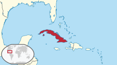
Cuba Location in World Map
Here is Cuba.
Location Information of Cuba
Cuba is an island country located in the Caribbean, known for its rich cultural heritage, tropical climate, and strategic position in the Gulf of Mexico. It is the largest island in the Caribbean, bordered by the Caribbean Sea to the south, the Atlantic Ocean to the north, and the Straits of Florida to the west, separating it from the United States. The island is part of the Greater Antilles, a group of islands in the western Caribbean.
Latitude and Longitude
Cuba is situated at approximately 21° 30′ N latitude and 80° 00′ W longitude. The island stretches about 1,250 kilometers (780 miles) from east to west and about 200 kilometers (120 miles) from north to south at its widest points. Its geographical location places Cuba in the heart of the Caribbean, making it a crucial point for maritime trade routes between the Atlantic Ocean and the Gulf of Mexico.
Capital City and Major Cities
Capital City: Havana (La Habana)
The capital city of Cuba is Havana, known in Spanish as La Habana. It is located on the island’s northern coast, along the Straits of Florida, and is the largest city in the country, with a population of over 2 million people in the city proper and approximately 2.5 million people in the metropolitan area. Havana is the cultural, political, and economic hub of Cuba. It is famous for its colonial architecture, vibrant street life, and historic significance. The Old Havana district, a UNESCO World Heritage site, is renowned for its Spanish colonial buildings, cobblestone streets, and significant landmarks such as the Malecón, Plaza de la Catedral, and El Capitolio.
Major Cities
- Santiago de Cuba Santiago de Cuba is the second-largest city in Cuba, located on the southeastern coast of the island. It is known as the birthplace of the Cuban Revolution and is a major cultural center. With a population of approximately 500,000 people, Santiago is rich in history, music, and Afro-Cuban culture. Notable sites include the Moncada Barracks, Céspedes Park, and Cuba’s oldest cathedral, La Iglesia de la Virgen de la Caridad del Cobre.
- Camagüey Camagüey is located in the central part of Cuba and is the country’s third-largest city. The city has a population of around 300,000 people. Camagüey is known for its well-preserved colonial architecture and its labyrinthine street plan, which was designed to confuse pirates. The Plaza de la Solidaridad, Iglesia de Nuestra Señora de la Candelaria, and Museo Camagüey are key attractions.
- Cienfuegos Cienfuegos, located on the southern coast of Cuba, is known for its French colonial architecture and beautiful bay. The city has a population of around 150,000 people. Cienfuegos is often referred to as the “Pearl of the South” because of its elegant streets, parks, and beautiful landscapes. Notable landmarks include the Parque José Martí, Palacio de Valle, and Castillo de Jagua.
- Santa Clara Santa Clara, located in the central part of Cuba, is a city of historical significance due to its role in the Cuban Revolution. With a population of about 200,000 people, it is known for the Che Guevara Mausoleum and the Memorial to the Revolution. The city is also a center for agriculture and education.
- Varadero Varadero is one of the most popular tourist destinations in Cuba, located on the Hicacos Peninsula in the northwestern part of the island. Known for its pristine beaches and resort facilities, Varadero attracts international visitors seeking sun, sand, and relaxation. It is also home to the Cueva de Saturno and Parque Josone.
Time Zone
Cuba follows Cuba Standard Time (CST), which is UTC -5 hours. During the summer months, Cuba observes Daylight Saving Time (DST) and switches to Cuba Daylight Time (CDT), which is UTC -4 hours. Like many countries in the region, Cuba follows the practice of moving the clocks forward in the spring and back in the fall.
Climate
Cuba enjoys a tropical climate throughout the year, with distinct wet and dry seasons. Due to its location near the equator, the country experiences warm temperatures year-round, making it a popular destination for tourists seeking warmth, especially during the winter months.
Tropical Climate (Year-Round Warmth)
- Average Temperatures: The average temperature throughout the year typically ranges between 25°C and 30°C (77°F and 86°F). The warmest months are from May to October, with average highs around 32°C (90°F). Cooler temperatures are usually found in the winter months of December to February, with average highs of around 26°C (79°F).
- Rainy Season: The rainy season typically runs from May to October, with the wettest months being June, July, and September. Thunderstorms are common during this time, especially in the afternoon, and the humidity is high. The country is also vulnerable to hurricanes during the peak of the hurricane season, which is from August to October.
- Dry Season: The dry season lasts from November to April, characterized by lower humidity and less rainfall. This is considered the peak tourist season, as the weather is more comfortable for outdoor activities and beach vacations.
Microclimates
Due to Cuba’s diverse topography, certain regions may experience different microclimates. Coastal regions and islands, such as Havana, Varadero, and the Isla de la Juventud, generally maintain moderate tropical conditions, while the mountainous regions of Sierra Maestra and Sierra del Escambray may experience cooler temperatures and more rainfall.
Economic Status
Cuba has a state-controlled socialist economy, which has evolved significantly since the 1970s under the leadership of the Cuban Communist Party. While Cuba remains one of the last socialist countries in the Western Hemisphere, it has gradually opened its economy in recent years, particularly in the areas of tourism, agriculture, and energy.
Key Sectors
- Tourism Tourism is a major component of the Cuban economy, with millions of visitors arriving annually from around the world. Cuba is known for its beaches, historical cities, colonial architecture, and vibrant culture. The country also attracts tourists for its eco-tourism opportunities, including visits to national parks and the Cuban biosphere reserves.
- Agriculture Agriculture has historically been the backbone of the Cuban economy. The country produces sugar, tobacco, citrus fruits, and coffee, as well as livestock and seafood. Sugarcane has been the most important crop in Cuba for centuries, and tobacco is particularly significant for the production of Cuban cigars, which are among the most highly regarded in the world.
- Biotechnology and Pharmaceuticals Cuba has invested heavily in the biotechnology and pharmaceutical sectors. The country has developed a reputation for producing high-quality vaccines and medical products, and the Cuban healthcare system is regarded as one of the best in the region.
- Renewable Energy Cuba is increasingly focusing on renewable energy sources, such as solar, wind, and biomass. The country aims to reduce its reliance on imported fossil fuels and diversify its energy mix. Cuba has already made significant investments in solar energy and aims to meet 24% of its energy needs from renewable sources by 2030.
- Manufacturing Cuba’s manufacturing sector is diverse, with key industries including food processing, beverages, tobacco, and pharmaceuticals. While the Cuban economy has been historically centralized, recent efforts to promote small businesses and private enterprises have begun to reshape the industrial landscape.
Challenges
The Cuban economy faces challenges such as U.S. sanctions, limited access to global financial markets, and a reliance on imports for many goods. The dual currency system in Cuba has created inefficiencies, although efforts have been made to unify the two currencies.
Tourist Attractions
Cuba is a top tourist destination, known for its unique blend of cultural heritage, natural beauty, and warm Caribbean atmosphere. Some of the top attractions include:
- Old Havana (Habana Vieja) The historic center of Havana, a UNESCO World Heritage site, is one of Cuba’s most visited destinations. Its cobbled streets, colorful colonial buildings, and vibrant Plaza de la Catedral are iconic landmarks. Visitors can explore El Capitolio, the National Museum of Fine Arts, and enjoy the lively culture that permeates the city.
- Varadero Beach Known for its pristine white-sand beaches and clear turquoise waters, Varadero is one of the most famous beach resorts in the Caribbean. It is perfect for sunbathing, water sports, and relaxation.
- Viñales Valley The Viñales Valley, located in the Pinar del Río province, is known for its dramatic limestone mountains, lush tobacco fields, and unique cave systems. It is a UNESCO World Heritage site and a popular spot for hiking, horseback riding, and exploring the natural landscape.
- Cuba’s National Parks Cuba is home to many national parks, including the Cuba Biosphere Reserve, which is rich in wildlife and plant species. The Ciénaga de Zapata National Park is a key destination for eco-tourism, birdwatching, and exploring wetlands.
- Che Guevara Memorial Located in Santa Clara, the Che Guevara Memorial is a significant historical site dedicated to the Argentine revolutionary leader’s life and legacy. The memorial includes a mausoleum and a museum.
Visa Requirements for U.S. Citizens
U.S. citizens wishing to travel to Cuba for tourism need to obtain a tourist visa or tourist card before arrival. The U.S. government has specific restrictions on travel to Cuba, and travelers must meet one of the 12 approved categories of travel, such as family visits, humanitarian projects, or educational activities. Tourism is not a permissible reason for travel under U.S. regulations, but many travelers qualify under categories such as people-to-people exchanges.
Travelers should also have a valid passport and a return ticket. The tourist card is typically obtained through airlines or travel agencies. U.S. citizens must also show proof of travel insurance.
Distance to Major U.S. Cities
- Distance to New York City The distance from New York City (JFK) to Havana, Cuba, is approximately 1,600 kilometers (1,000 miles). Flight time is generally 3 to 4 hours.
- Distance to Los Angeles The distance from Los Angeles (LAX) to Havana is approximately 3,800 kilometers (2,400 miles). Flight times are typically between 4.5 to 5 hours.
Cuba Facts
| Size | 110,860 km² |
| Residents | 11.34 million |
| Language | Spanish |
| Capital | Havana (La Habana) |
| Longest river | Río Cauto (343 km) |
| Highest mountain | Pico Turquino (1,974 m) |
| Currency | Cuban Peso (CUP) and Convertible Peso (CUC) |


