Where is Angola Located?
Where is Angola located on the map? Angola is an independent nation located in Central Africa. Check out the following images to see location of Angola on maps.
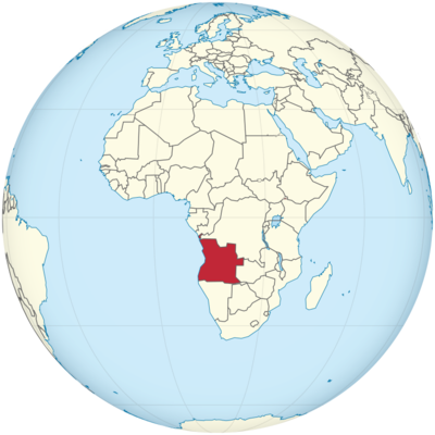
Angola Location in World Map
Here you can see the location, size and border states of Angola on the map.
Location Information of Angola
Latitude and Longitude
Angola is located in Southern Africa, bordered by the Atlantic Ocean to the west, Namibia to the south, Zambia to the east, and the Democratic Republic of the Congo (DRC) to the north. Its geographical coordinates are:
- Latitude: 11.2027° S
- Longitude: 17.8739° E
Angola’s position along the western coast of Africa places it within the tropical climate zone, while its interior regions are marked by a more diverse geography, ranging from the arid Namib Desert to the lush Congo Basin.
Capital City and Major Cities
- Capital City: LuandaLuanda is the capital and largest city of Angola. Situated on the Atlantic coast, Luanda is the political, cultural, and economic heart of the country. It is one of the fastest-growing cities in the world, driven by the country’s oil wealth. As the largest port and the center of most of Angola’s industries, Luanda serves as the gateway for business and international relations. The city’s coastal location provides stunning views of the ocean and is home to numerous beaches, resorts, and attractions.
- Major Cities:
- Huambo – Located in the central part of the country, Huambo is Angola’s second-largest city. It is known for its agricultural production, particularly in coffee, maize, and beans, and it also has a history of being an important center for education and commerce.
- Lobito – Situated along the Atlantic Ocean, Lobito is an important port city in Angola. It is known for its fishing industry and the Lobito railway, which connects Angola to neighboring countries, such as Zambia.
- Benguela – Another key port city along the Atlantic coast, Benguela plays an important role in Angola’s trade, particularly in the export of minerals and agricultural products.
- Namibe – Located on the southern coast, Namibe is known for its beaches and natural beauty. It also serves as an important center for fishing and agriculture.
- Cabinda – An exclave separated from the rest of the country by the DRC, Cabinda is a major oil-producing region of Angola. The city itself is the capital of the province and plays a crucial role in the country’s economy due to its oil reserves.
Time Zone
Angola operates on West Africa Time (WAT), which is UTC+1 throughout the year. The country does not observe daylight saving time, so the time remains consistent year-round. Angola shares its time zone with several other countries in West and Central Africa, including Nigeria, Cameroon, and the Republic of the Congo.
Climate
Angola’s climate is influenced by its diverse geography, ranging from tropical in the north to more arid in the south. The climate is characterized by two main seasons: the rainy season and the dry season. Below are the key climatic zones in Angola:
- Tropical Climate: The northern regions of Angola, including Luanda and areas near the Congo River, experience a tropical climate. The region receives substantial rainfall, particularly between October and April, with the wettest months being from December to February. The average temperatures in these areas range from 20°C (68°F) during the cooler months to around 30°C (86°F) in the hotter months.
- Arid Climate: The southern and southwestern regions of Angola, particularly in the provinces of Namibe and Cunene, experience a semi-arid to arid climate. These areas receive much less rainfall, and temperatures can soar to 35°C (95°F) or higher in the summer months. The Namib Desert, which extends into Angola, influences the dry conditions in the region.
- Central Plateau Climate: The central regions of Angola, including cities like Huambo, experience a more temperate climate, with cooler temperatures due to the higher elevation. These areas have a distinct wet season from November to March, followed by a dry season.
The variation in climate across the country allows for diverse ecosystems, ranging from tropical rainforests in the north to dry, desert-like landscapes in the south. Angola’s natural environment supports a wide range of wildlife, including elephants, lions, and several species of primates.
Economic Status
Angola’s economy is largely driven by natural resources, particularly oil, which accounts for a significant portion of the country’s GDP, exports, and government revenues. The country’s economic history has been marked by the aftermath of a long civil war (1975–2002), during which the economy suffered extensive damage. However, since the end of the war, Angola has experienced rapid economic growth, fueled by oil and mining sectors, despite facing challenges related to infrastructure, poverty, and corruption.
- Oil and Gas: Angola is one of the largest oil producers in Africa and a key member of the Organization of the Petroleum Exporting Countries (OPEC). The country’s oil sector accounts for over 90% of its export revenues and around 40% of GDP. Offshore oil fields, particularly in the deepwater regions, have become increasingly important in recent years. However, Angola faces challenges with fluctuating oil prices, which can impact the overall stability of its economy.
- Mining and Natural Resources: In addition to oil, Angola is rich in mineral resources, including diamonds, gold, and copper. The diamond mining industry, in particular, is a significant contributor to the country’s economy, with Angola being one of the world’s largest producers of diamonds. Other minerals, such as iron ore and phosphates, are also mined, but the sector is less developed than oil and gas.
- Agriculture: Agriculture in Angola has immense potential, but the sector has been underdeveloped due to the long civil war and a lack of investment in infrastructure. However, agriculture plays an essential role in providing food for the domestic market, with crops such as cassava, maize, beans, and bananas being cultivated in various regions. Livestock farming is also an important part of the economy.
- Infrastructure and Development: Angola is investing heavily in infrastructure development, including roads, railways, and energy. The country is working to diversify its economy and reduce dependence on oil by promoting industries such as agriculture, tourism, and manufacturing. However, challenges related to corruption, a lack of skilled labor, and a fragmented education system hinder the full potential of these sectors.
- Challenges: Angola faces significant economic challenges, including high levels of poverty, unemployment, and income inequality. The oil-dependent economy is vulnerable to price fluctuations, which can lead to financial instability. Additionally, the country’s infrastructure remains underdeveloped, particularly in rural areas, limiting access to essential services and opportunities for economic growth.
Tourist Attractions
Angola is a country with vast untapped tourism potential, offering a range of attractions for travelers interested in wildlife, history, culture, and nature. Some of Angola’s top tourist destinations include:
- Luanda: As the capital city, Luanda offers a blend of modern and historical attractions. The city is known for its vibrant cultural scene, including museums, theaters, and music venues. Key attractions in Luanda include the National Museum of Anthropology, the Fortaleza de São Miguel, and the Kinaxixi Market, which showcases local crafts. Luanda’s coastline offers beautiful beaches such as Ilha do Mussulo and Tenda.
- Kissama National Park: Located about 70 km south of Luanda, Kissama National Park is one of Angola’s premier wildlife reserves. The park is home to a variety of wildlife, including elephants, lions, giraffes, and antelopes. It is a popular destination for safaris, birdwatching, and eco-tourism.
- Tundavala Fissure: Situated in the southwestern part of Angola, the Tundavala Fissure is a dramatic geological feature that offers stunning views of the surrounding landscape. It is located in the Huila Highlands, a region known for its mountains, waterfalls, and unique flora and fauna.
- The Kalandula Falls: One of the largest waterfalls in Africa, Kalandula Falls is located in the northern part of Angola, in the Malanje province. The falls are surrounded by lush vegetation and offer a breathtaking natural landscape for visitors to explore.
- Lubango: Lubango, located in the southern part of the country, is known for its cool climate and scenic beauty. It is a gateway to the Tundavala Fissure and the Fenda de Tundavala, two popular tourist sites. The city is also home to Cristo Rei, a statue of Christ that offers panoramic views of the city and surrounding mountains.
- Catumbela: This coastal town, located near Benguela, is known for its beautiful beaches and rich cultural history. Catumbela is a great spot for visitors interested in exploring Angola’s coastal culture, seafood, and traditional African arts.
- Baía dos Tigres: This is one of Angola’s most picturesque natural settings, located along the southern coast near the border with Namibia. The bay is known for its pristine beaches and diverse marine life, making it an excellent location for water-based activities like fishing and scuba diving.
Visa Requirements for U.S. Citizens
U.S. citizens traveling to Angola for tourism or business purposes are required to obtain a visa. The visa application process generally involves the following steps:
- Visa Application Form: U.S. citizens must complete a visa application form, which can be obtained from the Embassy of Angola in Washington, D.C., or through consular services.
- Passport: A valid U.S. passport with at least six months of validity remaining beyond the intended departure date from Angola is required.
- Visa Fee: A visa fee must be paid as part of the application process. The amount varies depending on the type of visa (tourist, business, etc.) and the length of stay.
- Invitation Letter: For certain types of visas, such as business visas, an invitation letter from an Angolan sponsor may be required. This letter should include the purpose of the visit, the duration of stay, and the responsibilities of the sponsoring organization.
- Proof of Accommodation and Return Ticket: U.S. travelers may need to provide proof of accommodation in Angola, such as hotel reservations, and a return or onward travel ticket.
- Travel Insurance: It is advisable for travelers to obtain comprehensive travel insurance that covers health and emergencies during their stay in Angola.
Distance to Major U.S. Cities
The approximate distances from Angola’s capital, Luanda, to major U.S. cities are as follows:
- Distance to New York City: The approximate distance from Luanda to New York City is 4,600 miles (7,402 kilometers). The typical flight time is around 10 to 11 hours, with possible layovers in European cities such as Lisbon or Paris.
- Distance to Los Angeles: The distance from Luanda to Los Angeles is around 8,000 miles (12,875 kilometers). Flights typically take around 14 to 16 hours, depending on layovers and the specific flight path taken.
Angola Facts
| Size | 1,246,700 km² |
| Residents | 29.8 million |
| Languages | Portuguese and Umbundu, Kimbundu, Kikongo, TuChokwe, Ngangela, Oshivambo |
| Capital | Luanda |
| Longest river | Kunene (total length 1,207 km) |
| Highest mountain | Morro de Moco (2,619 m) |
| Currency | Kwanza |


